Saturday, November 24, 2007

Final Site Visit: Harvard Campus, Sever Hall and Fogg Museum


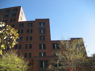
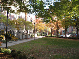
The site chosen is an exterior courtyard located in the Harvard Campus. There are many different courtyards at Harvard due to the fact that the campus is composed of many different and independent buildings located somewhat close to each other creating these enclosed exterior spaces throughout the whole campus.


The specific one chosen for this analysis is located at the Harvard Yard part of the Harvard Campus and is surrounded by the Sever Hall, the Robinson building and the Emerson building. Quincy street runs through one of the sides of this site (as seen in plan) and across from Quincy street the Fogg Art Museum is located.


Although an exterior and open space, this central courtyard feels very much enclosed. Surrounded by structurally similar buildings on every side it feels like a central enclosed space with its main gate right off Quincy Street. To add on to this enclosed space, the narrow passages between the buildings feel like hallways that one go through to the next room. The pathways emphasize this feeling directing you to these passages.


The space is also very symmetric and emphasizing this symmetry the paths and the landscape create these axial circulation lines that are part of a bigger pedestrian circulation system that connects all the Harvard Yard buildings. The gate is also very symmetrically positioned, facing directly the entrance to Sever Hall. Contributing to this symmetry is also the structure and form of the Sever Hall and the surrounding buildings themselves.


Although importantly situated, the FOGG Museum does not contribute as much to this space as the other 3 buildings surrounding it, because it is situated outside the gated wall and across the street. But it does complement the other 3 buildings and creates a forth wall to the space, although farther away and less strong.


Site Visit 9: Tent City, Back Bay (Nov 2, 2007)

Interior Courtyard


What makes this site unique is the design approach and the site forces taken into consideration through the project. Due to its specific and critical position and orientation, the building addresses two very important aspects of the site - A bigger scale and monumental characteristics of the downtown Boston area on one side and the small scale community of the back bay on the other side.


Relation between John Hancock Tower and Tent City Building - Downtown Scale


From the outside part of the building and on the downtown area, the building feels and looks massive and tall, like many other buildings in the surroundings. This area is noisy, with lots of pedestrian and motorized traffic running through. The green and open space between the tent city building and the Copley Place, in front of back bay MBTA station is a very public space for leisure and public circulation.

As you walk around the tent city building you notice the stepping down of its volumes to address the small community characteristics. The whole space feels different, more quiet, less movement and with a somewhat pedestrian quality, although there is motorized traffic running through. The central interior courtyard space created by the shape of the building that is wrapped around the block (somewhat more open towards the smaller scale community), feels much more a private area for the residents of the tent city building and the adjacent residential buildings. You definitely don't feel as you are in the middle of the city, the noise is broken down by the many buffer zones created by the lines of trees and the building itself.

The landscape itself helps creating this reduction in scale. By having these many trees casting shadows on the courtyard creating a great, warm green space to be used by the residents, that is protected of the noisy and busy city downtown by the tallest portion of the tent city building itself with 6 stories high. The building itself acts as a visual and sound barrier between the downtown area and the smaller scale community.


This interior space creates a great leisure, relaxed and safe space within the city which many times is not available and hard to find or even design due to the many issues of being in the city center.


Tuesday, October 30, 2007

Site Visit 8: Adams Square, Roslindale (Oct 26, 2007)

"People interacting with a space makes a place" ~ Herman Herzberger


The space we analyzed this past Friday in Roslindale fits perfectly into the architect Herman Herzberer's quote. Characterized by a great sense of centrality in the neighborhood it becomes a marker in Roslindale. It is a space used largely by the community and it is defined by the circulation and building volumes around it. The buildings surrounding the space are mainly commercial with some institutional buildings as well which emphasizes the idea of community oriented. The constant use of space by the community as a leisure or simply circulation creates the PLACE.


As you can see in the diagrammatic plan, there is a predominance of a central axis (red) that comes from Cummings Hwy and through the central open/green space towards northwest into the community. There are two opposite spaces at both ends of the axis. One towards northwest characterized by smaller scale buildings and more community oriented; the other characterized by the bigger scale boulevard (Cummings Hwy) towards southeast and away from the community.


Cummings Hwy brings a busy traffic circulation to the site as well as Washington street and at the intersection of these two streets there is a creation of a "gateway" defined by the two higher buildings on both corners (The old Power House and Roslindale Community Center) and emphasized by the central axis and the sense of direction.


The open/green space with all its small details emphasizes the sense of center, such as circulation paths and entry ways, vegetation and the circle design in the center. This space is surrounded by a transitional buffer zone of trees that protect and divide the space from the street traffic and noise creating a great space for community gatherings. It is also used by kids in the summer for different activities.


Thursday, October 25, 2007

Site Visit 7: Northeastern Campus (Oct 19, 2007)


The site we visited last Friday gives more a feeling of enclosure, compared to the urban rooms seen so far. The sense of enclosing walls given by the buildings around it and the way they are positioned create a really enclosed and secure space that is commonly used by the northeastern students as an exterior living space. During the summer you can see many students reading and studying or just relaxing in the central green space within these buildings. In the winter months the space is less crowded and is mainly used as circulation.


The curvature at the interior corners of the buildings emphasize even more the sense of enclosure within the space. If the space was covered it would resemble a larger scale of a room with 4 entrances.


As you can see in plan there are 4 gateways that connect the outside area of the city to this "interior" space. The gateways are organized orthogonally within 2 axis with 2 gateways facing each other in each of the ends of the axis. The 2 axis meet in the center emphasizing even more the sense of centralized space. These axis extend outside the analyzed area and are major axis within the university campus.


The main axis which starts at the main gateway that has the cylindrical shape on top goes all the way to Ruggles station establishing a visual connection from the street across the campus. (Image Above)


Some interesting details found on site.


Saturday, October 13, 2007

Site Visit 6: ICA, South Boston/Harbor/East Boston (Oct 12, 2007)


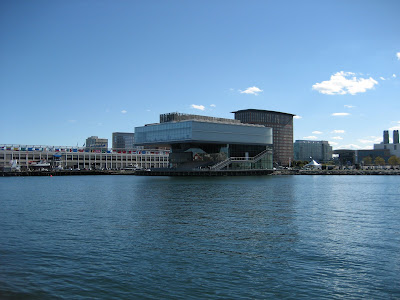
Our site analysis this time was definitely broader. From the Institute of Contemporary Art in South Boston we had to consider the exterior space defined by the ICA's exterior auditorium steps, the cantilever and East Boston on the other side across from the water.


Although the ICA's building itself was not part of the analysis it is a crucial element to understand this space. As you can see in the pictures and sketches the particular shape of the ICA's building closes itself inland and opens up towards the water forcing us to be aware of the other side and forget inland.


The cantilever emphasizes this feeling because it frames and directs you view forward.


The specific location of the ICA, as you can see in plan, also forces our view forward due to the fact that it is surrounded by the fan pier and the pier 4. These two piers also act as directors or fingers towards East Boston.


The space is strongly defined south wise by the ICA that acts as a barrier from the rest of the city. To the west as east as mentioned before the space limits itself with the piers that run in the same direction as the cantilever. The space is also defined by the ground plane that continues with the water and the cantilever that continues with the sky.
Considering all these limits or barriers that define the space, it is very loosely defined north wise. The only limit is East Boston that at the same time for being to far away can prolong the view. In my point of view I think this is the greatest characteristic of this space, being so strongly defined which gives a sense of enclosure but being so open and loose towards the water as if it is expanded through East Boston and the horizon.


This is a great space where you are protected by the sun with the enormous cantilever but still can experience a great summer or winter day (like Saturday). During rainy and windy days the cantilever wont protected you from the cold drizzle and wind coming water.